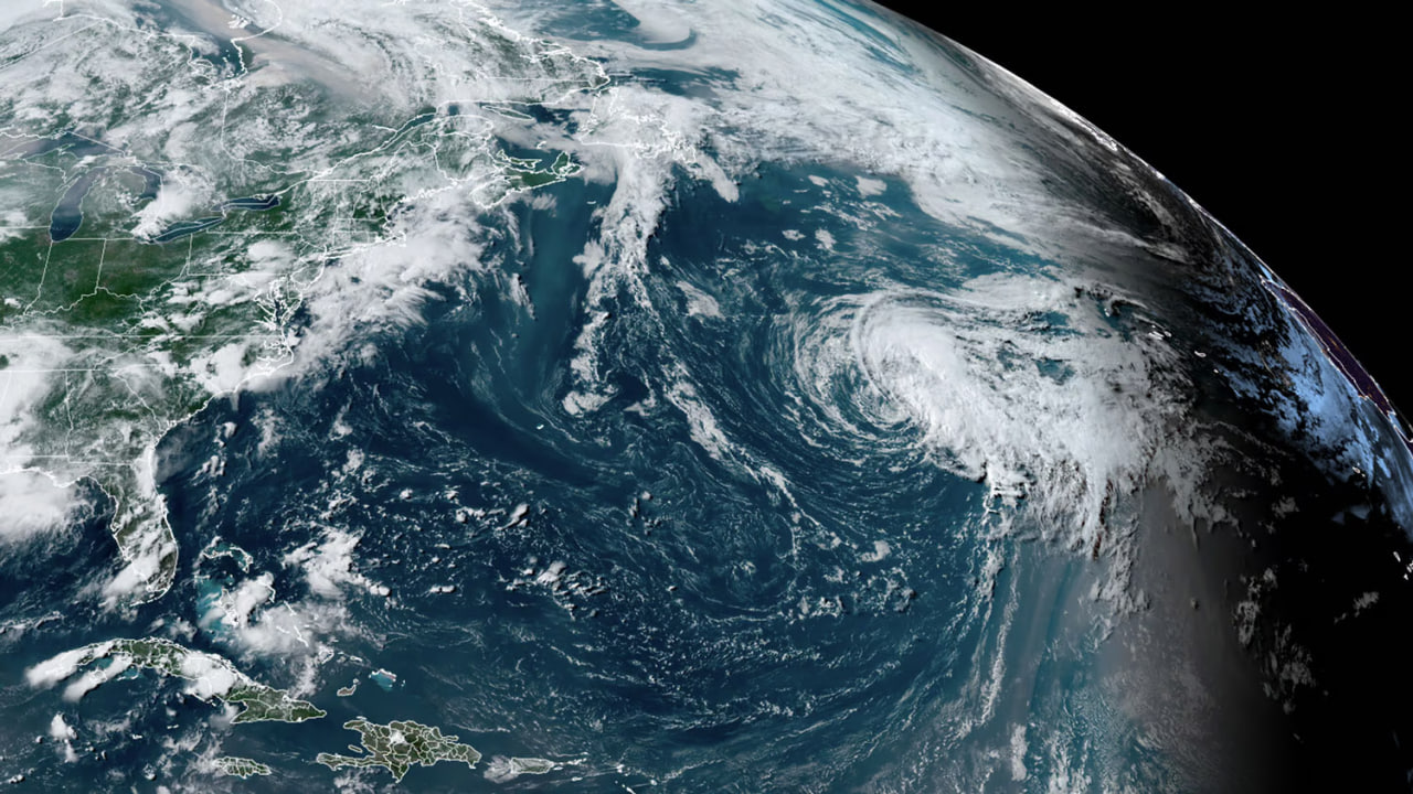
- Subtropical Storm Don in the Central Atlantic sends fun-size surf
- Frontal system contributes small windswell and annoying southerly wind this weekend
- Distant long-period South Atlantic swell joins the mix, too
The Atlantic tropics are back in action as Subtropical Storm Don formed with 45-knot winds in the pre-dawn hours this Friday. Sitting between Bermuda and the Azores, Don won’t threaten land and isn’t expected to move much in the coming days, leaving the door open for the system to linger in the Central Atlantic until this time next week. But before we get too excited by the prospect of a weeklong run of surf, let’s look at a few of the challenges ahead.
Although Don hangs around for a bit, it’s not expected to strengthen or weaken. So, no hurricane or depression, but there’s still 40-50-knot winds close to the center and decent fetch aimed our way. Any swell from Don would have to travel around 1,500 miles before reaching the East Coast, eating up a lot of the energy the storm spits out. So, don’t expect any pumping overhead surf from this round. It is, after all, still July.
Don drifts north over the weekend, then turns right and slowly tracks to the east on Sunday before turning more southeast early next week. Once that turn begins, Don will have a tough time sending swell back, however, models hint at Don taking a better track later next week, potentially setting up another round.
For surf, most zones won’t see swell from Subtropical Storm Don until the new week, while various other wave makers do their part to deliver waves this weekend. A front over the Eastern Seaboard puts small southerly windswell in the water for the Southeast and Northeast, but that comes along with bothersome southerly winds. The frontal boundary hangs just offshore into next week, so look for lighter winds and gradually improving conditions at some breaks.
Besides the windswell and easterly swell en route from Don, there’s a small E/ENE swell bump running the next day or two from older storm activity on the other side of the Atlantic. An inconsistent sample of long-period swell arrives this weekend, too, from a storm off South Africa early last week. It’ll take some patience, but that action from the Southern Hemi should offer up the best sets with these other sources helping to break up the longer Southern Hemi lines, or even offer a combo peak.
None of these swells are bangers on their own, but the mix of directions and periods keeps boards in the water. And that’s a good thing in the middle of July. Most spots are in the 1-2-3′ range with better sets developing Sunday for exposed breaks around the Northeast and on Hatteras Island. Overall, the surf looks best next week as Don’s swell spreads in, increasing the size as conditions gradually improve along the northern half of the coast.
Subtropical Storm Don is already exceeding model expectations — be sure to follow your local forecast for the latest updates to see if the trend continues.
Source: Surfline


