Conditions off the Coromandel’s east coast are rapidly deteriorating ahead of Cyclone Hale making landfall.
The tropical storm, New Zealand’s first of 2023, is expected to hit the North Island tonight – earlier than previously forecast – and people are warned to brace themselves for gale-force winds and extensive heavy rain that could last until Thursday morning.
The wind has risen in the past two hours and white caps are visible on the increasingly choppy sea hundreds of metres out from the Whitianga shoreline. The entire area is cloaked in a misty gloom.
Late this afternoon a stream of traffic, many towing boats and laden with camping gear, was seen heading away from the Coromandel.
It comes as MetService is warning that eastward-facing parts of the North Island, like Coromandel and Gisborne that were drenched last week, “are again in the firing line”.
Heavy rain warnings have been issued for those regions as well as many others including Hawke’s Bay.
People are urged to keep up to date with the latest forecasts and warnings and stay alert to bulletins from local authorities.
“Cyclone Hale is approaching the North Island today, bringing rain and strong east to southeast winds to many areas,” MetService says.
“This is likely to be a significant adverse weather even with widespread effects, and more areas are likely to be added as the system moves closer and its exact track and intensity becomes more certain.”
Waka Kotahi NZ Transport Agency has asked people to avoid unnecessary travel from tonight until Wednesday morning.
Acting national manager maintenance and operations Jaclyn Hankin said heavy rain could cause surface flooding, trigger slips and cause streams and rivers to rise rapidly, which would require the agency to close some state highways.
Auckland and eastern Northland is also under a heavy rain watch, with forecast wind gusts of 75-85km/h which may result in speed reductions and lane closures on the Auckland Harbour Bridge tomorrow and on Wednesday.
“Stay alert for unreported hazards, such as surface flooding, slips, fallen trees and branches, and downed powerlines,” Hankin said.
“If you must travel, slow down and maintain a greater following distance between your vehicle and the one in front.”
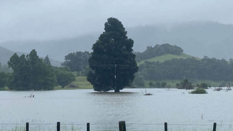
East Coast settlements are being warned they may be cut off for days, with Civil Defence urging North Island residents to keep an eye on the approaching storm, with fears of widespread flooding and beaches hammered by dangerous 6m swells.
Everyone in the Coromandel is being warned to take shelter by this evening and be prepared to “ride out” ex-tropical cyclone Hale for 24 hours, with the North Island to take a direct hit from the approaching storm.
New Zealand’s first tropical storm of 2023 is expected to wreak more havoc across the top of the country from tonight with heavy rain to batter Gisborne and Coromandel, despite Hale being downgraded to a former tropical cyclone.
MetSrvice warned this morning that severe weather will blast across northern regions over the coming two days, starting this evening, with heavy rain from tonight and gales tomorrow.
Easterly swells of up to 6m are forecast to pound east-facing coasts from Northland to Wairarapa on Tuesday and Wednesday. MetService warns it could lead to coastal flooding and erosion around high tide.
New Zealand Civil Defence today told people to make an emergency plan and prepare homes ahead of the tropical blast which was likely to bring heavy rain, strong winds and dangerous coastal conditions.
“If you are in Tairāwhiti, Hawke’s Bay or the Coromandel Peninsula, stay up to date by checking MetService warnings and following your local Civil Defence Emergency Management group on social media.”
With destructive gales and flood-threatening levels of rain forecast to hit much of the upper North Island in coming hours the national defence organisation advised people to secure items around properties and bring pets indoors, ensure livestock were gathered in a safe place. It also advised to secure boats or boat trailers.
Tairāwhiti Civil Defence warned locals across the region to be prepared and have a plan in case they needed to evacuate.
“If you know you could possibly get cut off, make plans to move now or be prepared with enough supplies for three days, including medication.
“If you’re camping in an exposed coastal area you should consider moving now.”
It said all unsealed roads across the region would be closed to heavy freight trucks from 8pm tonight.
This morning Thames-Coromandel District Council said those staying on the eastern seaboard needed to keep up-to-date with developments and be somewhere safe by tonight, “ready to ride this out for at least 24 hours”.
Weatherwatch.co.nz says the cyclone is likely to affect nearly all northern and eastern regions of the North Island in the coming 24 hours.
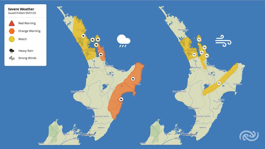
A swathe of new weather alerts have been issued this morning, spanning Northland to Hawke’s Bay.
Heavy rain warnings have been issued for Coromandel, Gisborne and Hawke’s Bay with torrential downpours expected tomorrow afternoon, bringing with it the threat of flooding and slips.
A heavy rain watch is now in place for Auckland, southern and eastern Northland and Great Barrier Island, with rain to start falling tonight.
There is also a strong wind watch in effect for Auckland, Coromandel and Bay of Plenty, with gales at times.
Coromandel civil defence controller Garry Towler said workers were out clearing roads from last week’s storm but said extreme care was needed with further slips and tree falls possible due to saturated ground.
A heavy rain watch is in place for Gisborne and the Coromandel from Monday evening until Tuesday night, where rainfall amounts could exceed warning criteria, MetService said. More rain is expected to hit Auckland in the coming days.
This morning Weatherwatch.co.nz said the North Island was in for a direct hit from the ex-tropical cyclone.
The forecaster said Hale was expected to strengthen into an ex-tropical storm in the New Zealand area tomorrow, bringing a surge of severe gales and heavy rain across the North Island for two days, before leaving by Thursday.
The centre of the low was expected to move into Northland, Auckland, Coromandel Peninsula and Bay of Plenty on Tuesday night.
The areas most in the storm’s path included eastern parts of Northland, North Auckland, eastern Waikato, Coromandel, Bay of Plenty, East Cape and Gisborne, Hawke’s Bay, Wairarapa and the Cook Strait.
The storm brought with it the risk of slips, flooding, power cuts, trees down and road closures, said weatherwatch.co.nz.
MetService’s latest models predict Cyclone Hale will hit the Coromandel Peninsula before travelling to the Waikato, through Taupō and hooking back towards Hawke’s Bay.
MetService said people should keep up to date with forecasts as more severe weather warnings and watches will be issued for weather associated with Cyclone Hale closer to the time.
Towler said the eastern seaboard in particular was in for a hammering early this week.
“We are not sugar coating this one, it will hit hard and likely cause coastal damage as well as the usual slips, surface flooding and power outages”.
The ex-tropical system was forecast to dump more than 230mm of rain in 24 hours with easterly gales and gusts exceeding 110km/h.
Towler said impacts would be felt from this evening, peaking on Tuesday and passing through by Wednesday afternoon.
The Council’s coastal scientists forecast storm surges of up to 30cm or more above the three high tides over this time.
“The main areas of concern are erosion and inundation at Brophy’s and Buffalo beaches in Whitianga, erosion and structure damage across beaches all the way down to Whangamatā,” said Towler.
“Everyone on the Coromandel, especially on the eastern side needs to stay up to date and be somewhere safe by Monday night, ready to ride this out for at least 24 hours,” Towler said.
Cyclone Hale was located southwest of New Caledonia at midday on Sunday and is expected to approach the northeast of the North Island on Monday and Tuesday.
It will then likely pass southwards over or near the eastern North Island on Wednesday, before moving away to the east.
Ahead of tonight’s forecast cyclone, forestry operators in Northland, Gisborne and Hawkes Bay were asked to stop work in severe weather.
“Strong winds and heavy rain can make forestry operations dangerous,” said Safetree chief executive Joe Akari.
”Please take heed of any MetService or Civil Defence warnings issued.”
AA Insrance head of home claims Tom Bartlett said people should check their properties before the cyclone hits.
“With heavy rain on the way for parts of the country which have seen a lot of rainfall already this year, we’re encouraging people to get out and check their properties while it is safe to do so, especially areas of your house that are prone to flooding,” Bartlett said.
Rural property owners should check that their property is secure and livestock moved to sheltered areas, he said.
Any items that could get caught up in the wind such as trampolines should be tied down, and if possible move outdoor furniture and barbecues inside or under cover.
Tower CEO Blair Turnbull says people with household emergency plans should be prepared to put them into action.
“Be prepared to evacuate quickly if it becomes necessary… make sure you do so safely and your property is secure by locking all doors and windows,” he said.
“We’re aware of the ways climate change is affecting our communities. Our data clearly shows the frequency of large events and the severity of the damage they cause, increasing over time.”
Source : NZHerald